

PI-CASC
Geospatial
PI-CASC
Pacific Islands Climate Science Center |
|---|
presents the Pacific Climate Science Webinar Series
Science for coastal adaptation:
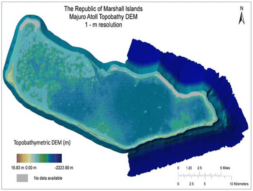
Creating a high-resolution digital elevation model for Majuro, RMI
with Jeffrey Danielson, USGS Earth Resources Observation and Science Center
and Monica Palaseanu-Lovejoy, USGS Eastern Geographic Science Center
Wednesday, October 5th at 11:00 am HST
[2 pm PDT/5 pm EDT/9 pm UTC/Oct 26th, 7am ChST]
 Most atolls average less than 3 m in elevation and thus, with all island coastal communities,
are extremely vulnerable to sea-level rise, storm surges, high sruf, king tides, and
combinations of these factors. Coastal topographic and bathymetrics maps with high
spatial resolution (~1 m grids) and high vertical accuracy are critically lacking
for many Pacific Island atolls but are needed to assess their vulnerability to climate
change impacts related to sea-level rise. Such maps would facilitate inundation and
infiltration modeling, marine and coastal resource management, and hazard adaptaion
efforts. The objections of this project are 1) to generate baseline data for visualizing
and mapping surface landforms, and 2) to analyze the impacts of inundation events
on atoll geography, shallow freshwater lenses, and traditional agroforestry.
Most atolls average less than 3 m in elevation and thus, with all island coastal communities,
are extremely vulnerable to sea-level rise, storm surges, high sruf, king tides, and
combinations of these factors. Coastal topographic and bathymetrics maps with high
spatial resolution (~1 m grids) and high vertical accuracy are critically lacking
for many Pacific Island atolls but are needed to assess their vulnerability to climate
change impacts related to sea-level rise. Such maps would facilitate inundation and
infiltration modeling, marine and coastal resource management, and hazard adaptaion
efforts. The objections of this project are 1) to generate baseline data for visualizing
and mapping surface landforms, and 2) to analyze the impacts of inundation events
on atoll geography, shallow freshwater lenses, and traditional agroforestry.
To these ends, topographic and reference control data were collected on Majuro Atoll during a 10-day field survey in September 2016 as part of a collaboration between the Pacific Islands Climate Science Center, the USGS Coastal National Elevation Database Applications Project, the University of Guam, and NOAA's National Geodetic Survey. The final topographic-bathymetric digital elevation map for Majuro Atoll is derived from various data sources (charts, soundings, acoustic sonar, and satellite and unmanned aircraft system imagery) spanning over 70 years (1944-2016) of data collection across Majuro Atoll. During this webinar, we will discuss our methods for the acquisition, processing, and validation of the topographic and bathymetric data, as well as the data integration to generate a seamless elevation product. Information about how the access these maps will also be provided to enable further commnunity planning and resource management.
Webinar and Call-in information for PI-CSC Webinar
Date: Wednesday, October 25th, 2017
Time: 11:00 am, Hawaii (Honolulu, GMT – 10:00)